For a couple of years now, I've wanted to hike the Sierra Azul Open Space Preserve, which sits snugly in between Almaden Quicksilver County Park in San Jose and Lexington Reservoir in Los Gatos.
Yesterday, I finally managed to do it. The two deciding factors were that I have the week off of work and the fact that the County Office of Education (my employers) are sponsoring a step challenge through the Power of Vitality website.
I parked my car in downtown Los Gatos, wondering whether anybody would notice it sitting in a lot with a 3 hour parking limit when I knew it was going to be parked there over twice as long. Jeanine drove me to the Hicks Road trailhead, where Sierra Azul abuts Alamaden Quicksilver, but didn't accompany me on the hike because hiking for 15 miles isn't her idea of fun.
I started down Woods trail under cloudy skies. It was a bit chilly, but I soon warmed up. For fun, I decided to count all of the animals seen during the hike too.
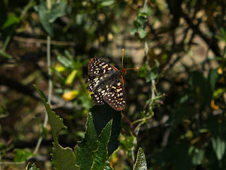
Woods trail starts off fairly level and shady, passing by wooded riparian areas, with lots of oak, Bay Laurel, and Madrone trees, to metnion a few. After a few miles, the trail starts ascending toward the 3000 foot peak of El Sombroso. The clouds burned off, revealing the old communications cube at the top of Mt. Umunhum. Spring flowers brightened the trailside, and were sometimes nearly obscured by clouds of butterflies (mostly Variable Checkerspots).
I stopped for a brief lunch near El Sombroso. The peak itself isn't that exciting, especially since there is a row of power line pylons marching across it. The views of the South Bay were a bit hazy, but still pretty amazing. At this point, my Fitbit informed me that I'd ascended 1,640 feet. Most of the ascent was gradual, with only a few steep grades toward the end.
After lunch, I continued on Woods trail along the ridge line, and then, at the next junction, headed to the left down Limekiln trail. There was some shade, and a number of stretched of exposed chaparral. This wouldn't be fun in the heat of Summer, but today it wasn't too bad. After Limekiln crosses Priest Rock trail, it ascends steeply and enters the forest. The last time I hiked this stretch, it was in the opposite direction and not too fun (although I did find a Ringneck snake that time).
The trail ends along Alma Bridge road at Lexington Reservoir. I hiked counter clockwise along the road until I could cross and head down Los Gatos Creek trail. This is where I saw the first people of the day. I hadn't seen a single hiker all the way across Sierra Azul. Suddenly, there were bikers and joggers everywhere. There were also people standing in the middle of the trail, obliviously texting. There is also Highway 17 with cars roaring by on the left. I picked up my pace and finished the final stretch. Back at my car, I was relieved to find that I hadn't gotten a ticket.
Fitbit says I walked 32,897 steps, with a 2100 foot elevation gain (lots of ups and downs past El Sombroso), in 15.2 miles.
And now, here are some photos:
Mt. Umunhum slowly revealed as the clouds burn off.
Variable Checkerspot.
Mt. Umunhum again.
Fernald's Iris.
Looking down at the South Bay.
Heading west on Woods trail, just past the summit of El Sombroso.
Dead tree reaching for overhead power lines. The area looked like there was a small fire there at some point.
California Alligator Lizard. It let me get pretty close before indignantly scuttling off into nearby bushes.
A minor rockfall along Limekiln trail.
Downhill on Limekiln, approaching Lexington Reservoir.
My animal count for the hike, not including insects, animals heard but not seen, or seen but not identified (birds in the distance, etc.):
Mourning Dove (3)
Dark-Eyed Junco (6)
Anna's Hummingbird (5)
Spotted Towhee (3)
Western Gray Squirrel (1)
Merriam's Chipmunk (1)
Western Fence Lizard (16)
Turkey Vulture (4) - one of them burst out of the shrubbery directly in front of me. It was pretty cool.
Whiptail (1)
California Alligator Lizard (1)
Black-tailed Deer (1)
California Quail (1)
Great Blue Heron (1)
Mallard (6)
California Ground Squirrel (1)
Brush Rabbit (1)
The hike took 6 hours and 35 minutes.
There is a convenient Sierra Azul checklist on iNaturalist. I've just recently started investigating this site, and it's a great resource for identification purposes, and a fine enabler of citizen science.


No comments:
Post a Comment